| Datum | Vulkan | VEI | Region | Todesopfer | Schaden | |
|---|---|---|---|---|---|---|
| Santiaguito SW flank (Santiaguito) | 3 | Guatemala | unbekannt | |||
| Fuego | 3 | Guatemala (Central America) | unbekannt | |||
| Pacaya MacKenney Crater | 1 | Guatemala | unbekannt | |||
| 2021 Mär (Ausbruch | Pacaya | 1 | Guatemala | leicht | Info | |
| 2018 Jun 3 (Ausbruch | Fuego | 2 | Guatemala (Central America) | 201 | sehr schwer | Info |
| 2017 Jun 6 (Ausbruch | Fuego | 2 | Guatemala (Central America) | mittel | Info | |
| Pacaya MacKenney Crater | 1 | Guatemala | unbekannt | |||
| Pacaya MacKenney Crater | 2 | Guatemala | unbekannt | |||
| Pacaya MacKenney Cone | 3 | Guatemala | unbekannt | |||
| 2010 Mai 27 (Eruptionsepisode | Pacaya | 1 | Guatemala | 1 | leicht | Info |
| Pacaya MacKenney Cone and lower S flank | 3? | Guatemala | unbekannt | |||
| Pacaya MacKenney Crater | 1? | Guatemala | unbekannt | |||
| Pacaya MacKenney Crater | 1 | Guatemala | unbekannt | |||
| Pacaya MacKenney Crater | 1 | Guatemala | unbekannt | |||
| Fuego | 2 | Guatemala (Central America) | unbekannt | |||
| Pacaya MacKenney Crater and flank vents | 3 | Guatemala | unbekannt | |||
| 1995 Apr 7 (Ausbruch | Pacaya | 3 | Guatemala | 1 | leicht | Info |
| 1990 Jul 19 (Ausbruch | Santiaguito | 3 | Guatemala | 4 | unbekannt | Info |
| Pacaya MacKenney Crater and flank vents | 3 | Guatemala | unbekannt | |||
| Fuego | 1 | Guatemala (Central America) | unbekannt | |||
| 1987 Jan 25 (Ausbruch | Pacaya | 3 | Guatemala | leicht | Info | |
| Fuego | 2 | Guatemala (Central America) | unbekannt | |||
| 1978 Sep 2 (Ausbruch | Santiaguito | 3 | Guatemala | 1 | unbekannt | Info |
| Fuego | 1 | Guatemala (Central America) | unbekannt | |||
| Fuego | 1 | Guatemala (Central America) | unbekannt | |||
| Fuego | 4 | Guatemala (Central America) | unbekannt | |||
| 1974 Okt 10 (Ausbruch | Fuego | 4 | Guatemala (Central America) | 1-50 (*) | mittel | Info |
| Fuego | 2 | Guatemala (Central America) | unbekannt | |||
| Acatenango Pico Central-Yepocapa saddle | 1 | Guatemala | unbekannt | |||
| Fuego | 3 | Guatemala (Central America) | unbekannt | |||
| 1971 Sep 14 (Ausbruch | Fuego | 3 | Guatemala (Central America) | 10 | unbekannt | Info |
| Fuego | 2 | Guatemala (Central America) | unbekannt | |||
| Fuego | 3 | Guatemala (Central America) | unbekannt | |||
| Fuego | 3 | Guatemala (Central America) | unbekannt | |||
| Fuego | 3 | Guatemala (Central America) | unbekannt | |||
| 1963 Sep 28 (Ausbruch | Fuego | 3 | Guatemala (Central America) | 7 | unbekannt | Info |
| Fuego | 3 | Guatemala (Central America) | unbekannt | |||
| Pacaya Cachajinas vent (South flank, 1860 m) | 2 | Guatemala | unbekannt | |||
| Fuego | 3 | Guatemala (Central America) | unbekannt | |||
| Fuego | 1 | Guatemala (Central America) | unbekannt | |||
| Fuego | 3 | Guatemala (Central America) | unbekannt | |||
| Fuego | 2 | Guatemala (Central America) | unbekannt | |||
| Fuego | 2 | Guatemala (Central America) | unbekannt | |||
| Fuego | 2 | Guatemala (Central America) | unbekannt | |||
| Fuego | 4 | Guatemala (Central America) | unbekannt | |||
| 1929 Nov 2 (Ausbruch | Santiaguito | 3 | Guatemala | 200 | unbekannt | Info |
| Acatenango Pico Central | 2 | Guatemala | unbekannt | |||
| Acatenango North slope of Pico Central | 3 | Guatemala | unbekannt | |||
| Santiaguito SW flank (east end of 1902 crater) | 2 | Guatemala | unbekannt | |||
| Santiaguito SW flank | 6? | Guatemala | unbekannt | |||
| 1902 Okt 25 (Ausbruch | Santiaguito | 6 | Guatemala | 10,000 | mittel | Info |
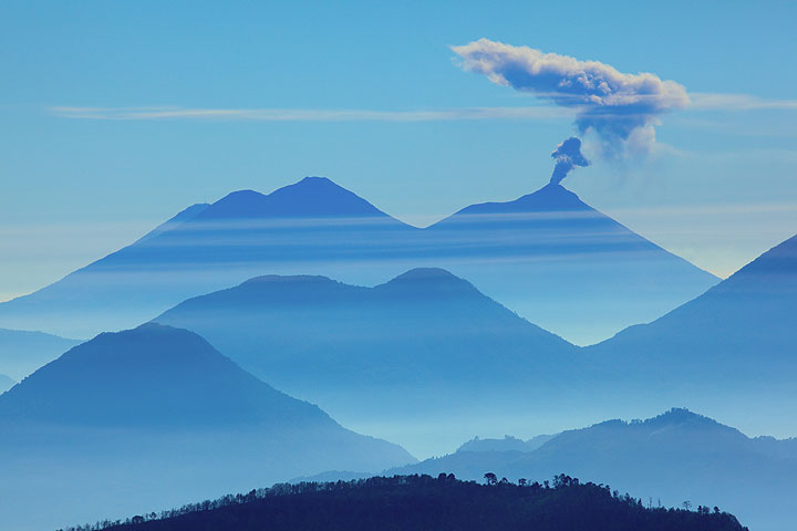
Der letzte Vulkanausbruch in Guatemala ereignete sich am Vulkan Pacaya volcano während 2015 - 2021.
Der erste historisch belegte Vulkanausbruch war um 1469 AD am Vulkan Atitlán.
Seit 1469 AD gab es in Guatemala mindestens 102 historisch belegte Ausbrüche. Das bedeutet, dass im Schnitt ein Vulkan ungefähr alle 5.5 Jahre ausbricht.
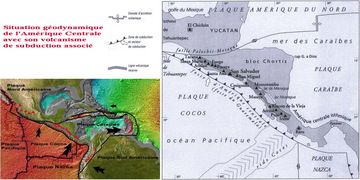
Guatemala ist vulkanisch gesehen äußerst aktiv: Seit 1900 sind mindestens 4 Vulkane in Guatemala aktiv gewesen. Fast jedes Jahr ist mindestens ein Vulkan in Guatemala aktiv gewesen. Der letzte Vulkan, der in Guatemala ausgebrochen ist, ist der Vulkan Pacaya. Er war von 2015 bis 2021 aktiv und ruht seitdem wieder, d.h. seit 4 Jahren.
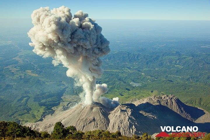
Der größte Vulkanausbruch in Guatemala in geschichtlicher Zeit ereignete sich am Vulkan Santiaguito im Jahr 1902. Er gilt als plinianischer Ausbruch mit einer Stärke von 6 auf der VEI (Volcanic Explosivity Index) Skala. Ausbrüche dieser Stärke haben oft schwerwiegende weitreichende Folgen für die betroffene Region.
| Datum und Uhrzeit | Mag / Tiefe | Nächster Vulkan / Ort | |||
|---|---|---|---|---|---|
| 22. Mai. 09:08 (Guatemala) | 4.5 44 km | 73 km S von | Nordpazifik, 70 km südlich von Mazatenango, Suchitepeque, Guatemala I FELT IT - 6 Berichte | Info | |
| Mittwoch, 21. Mai 2025 GMT (1 Beben) | |||||
| 21. Mai. 01:31 (Merida) | 4.2 105 km | 19 km W von | 18 km nördlich von Tapachula, Chiapas, Mexiko I FELT IT | Info | |
| Montag, 19. Mai 2025 GMT (1 Beben) | |||||
| 19. Mai. 07:56 (GMT -6) | 4.1 47 km | 128 km SW von | Nordpazifik, 91 km südwestlich von La Gomera, Escuintla, Guatemala I FELT IT | Info | |
| Sonntag, 18. Mai 2025 GMT (3 Beben) | |||||
| 18. Mai. 11:12 (GMT -6) | 4.1 81 km | 111 km SW von | Nordpazifik, 85 km südwestlich von Retalhuleu, Retalhuleu, Guatemala I FELT IT | Info | |
| 18. Mai. 10:59 (GMT -6) | 4.2 14 km | 138 km SW von | Nordpazifik, 74 km südwestlich von Champerico, Retalhuleu, Guatemala I FELT IT | Info | |
| 18. Mai. 06:33 (GMT -6) | 4.0 6.9 km | 137 km SW von | Nordpazifik, 74 km südwestlich von Champerico, Retalhuleu, Guatemala I FELT IT | Info | |
| Datum | Mag | Region | Todesopfer | Schaden | |
|---|---|---|---|---|---|
| 2012 Nov 7 | 7.3 | San Marcos, San Cristobal Cochu | 48 | sehr schwer | Info |
| 1991 Sep 18 | 6.2 | Guatemala City, Pachuta, Solola | 25 | schwer | Info |
| 1978 Jul 29 | 4.5 | Patzun | 17 | mittel | Info |
| 1976 Feb 4 | 7.5 | Chimaltenango, Guatemala City | 23,000 | katastrophal | Info |
| 1917 Dec 26 | 6.0 | Guatemala City | 2,650 | sehr schwer | Info |
| 1902 Apr 19 | 7.5 | Quezaltenango, San Marcos | 2,000 | schwer | Info |
Das tödlichste Erdbeben in Guatemala seit 1900 war das Erdbeben der Stärke 7.5 in ![]() Guatemala, Departamento Izabal am 4. Februar 1976. Es forderte 23,000 Todesopfer und 76,000 Verletzte. Auch ein Tsunami wurde durch das Beben ausgelöst und trug zu dessen zerstörerischen Auswirkungen bei. Dies war das verheerendste je aufgezeichnete Erdbeben in Guatemala.
Guatemala, Departamento Izabal am 4. Februar 1976. Es forderte 23,000 Todesopfer und 76,000 Verletzte. Auch ein Tsunami wurde durch das Beben ausgelöst und trug zu dessen zerstörerischen Auswirkungen bei. Dies war das verheerendste je aufgezeichnete Erdbeben in Guatemala.
Insgesamt forderten Erdbeben seit 1900 eine geschätzte Zahl von 28,000 Todesopfern; es sind mindestens 15 tödliche Beben in diesem Zeitraum bekannt.
Der gesamte wirtschaftliche Schaden, der seit 1900 von Erdbeben verursacht wurde, kann auf etwa $2.6 Milliarden US-Dollar geschätzt werden.