| Date | Volcano | VEI | Region | Deaths | Damage | |
|---|---|---|---|---|---|---|
| Santiaguito SW flank (Santiaguito) | 3 | Guatemala | ||||
| Fuego | 3 | Guatemala (Central America) | ||||
| Pacaya MacKenney Crater | 1 | Guatemala | ||||
| 2021 Mar (eruption | Pacaya | 1 | Guatemala | light | Info | |
| 2018 Jun 3 (eruption | Fuego | 2 | Guatemala (Central America) | 201 | very heavy | Info |
| 2017 Jun 6 (eruption | Fuego | 2 | Guatemala (Central America) | moderate | Info | |
| Pacaya MacKenney Crater | 1 | Guatemala | ||||
| Pacaya MacKenney Crater | 2 | Guatemala | ||||
| Pacaya MacKenney Cone | 3 | Guatemala | ||||
| 2010 May 27 (eruptive episode | Pacaya | 1 | Guatemala | 1 | light | Info |
| Pacaya MacKenney Cone and lower S flank | 3? | Guatemala | ||||
| Pacaya MacKenney Crater | 1? | Guatemala | ||||
| Pacaya MacKenney Crater | 1 | Guatemala | ||||
| Pacaya MacKenney Crater | 1 | Guatemala | ||||
| Fuego | 2 | Guatemala (Central America) | ||||
| Pacaya MacKenney Crater and flank vents | 3 | Guatemala | ||||
| 1995 Apr 7 (eruption | Pacaya | 3 | Guatemala | 1 | light | Info |
| 1990 Jul 19 (eruption | Santiaguito | 3 | Guatemala | 4 | Info | |
| Pacaya MacKenney Crater and flank vents | 3 | Guatemala | ||||
| Fuego | 1 | Guatemala (Central America) | ||||
| 1987 Jan 25 (eruption | Pacaya | 3 | Guatemala | light | Info | |
| Fuego | 2 | Guatemala (Central America) | ||||
| 1978 Sep 2 (eruption | Santiaguito | 3 | Guatemala | 1 | Info | |
| Fuego | 1 | Guatemala (Central America) | ||||
| Fuego | 1 | Guatemala (Central America) | ||||
| Fuego | 4 | Guatemala (Central America) | ||||
| 1974 Oct 10 (eruption | Fuego | 4 | Guatemala (Central America) | 1-50 (*) | moderate | Info |
| Fuego | 2 | Guatemala (Central America) | ||||
| Acatenango Pico Central-Yepocapa saddle | 1 | Guatemala | ||||
| Fuego | 3 | Guatemala (Central America) | ||||
| 1971 Sep 14 (eruption | Fuego | 3 | Guatemala (Central America) | 10 | Info | |
| Fuego | 2 | Guatemala (Central America) | ||||
| Fuego | 3 | Guatemala (Central America) | ||||
| Fuego | 3 | Guatemala (Central America) | ||||
| Fuego | 3 | Guatemala (Central America) | ||||
| 1963 Sep 28 (eruption | Fuego | 3 | Guatemala (Central America) | 7 | Info | |
| Fuego | 3 | Guatemala (Central America) | ||||
| Pacaya Cachajinas vent (South flank, 1860 m) | 2 | Guatemala | ||||
| Fuego | 3 | Guatemala (Central America) | ||||
| Fuego | 1 | Guatemala (Central America) | ||||
| Fuego | 3 | Guatemala (Central America) | ||||
| Fuego | 2 | Guatemala (Central America) | ||||
| Fuego | 2 | Guatemala (Central America) | ||||
| Fuego | 2 | Guatemala (Central America) | ||||
| Fuego | 4 | Guatemala (Central America) | ||||
| 1929 Nov 2 (eruption | Santiaguito | 3 | Guatemala | 200 | Info | |
| Acatenango Pico Central | 2 | Guatemala | ||||
| Acatenango North slope of Pico Central | 3 | Guatemala | ||||
| Santiaguito SW flank (east end of 1902 crater) | 2 | Guatemala | ||||
| Santiaguito SW flank | 6? | Guatemala | ||||
| 1902 Oct 25 (eruption | Santiaguito | 6 | Guatemala | 10,000 | moderate | Info |
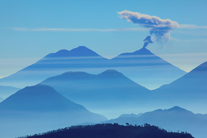
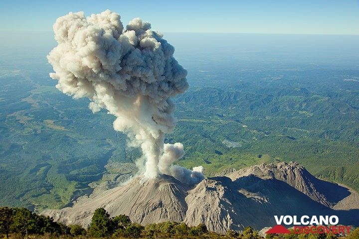
The last volcanic eruption in Guatemala was from Pacaya volcano during 2015 - 2021.
The first historically documented eruption occurred around 1469 AD from Atitlán volcano.
Since 1469 AD, Guatemala has seen at least 102 historically documented eruptions. This means that a volcano erupts on average every 5.5 years.
Guatemala is volcanically extremely active: Since 1900, at least 4 volcanoes in Guatemala have been active. Almost every year, at least one volcano has erupted in Guatemala. The last volcano to erupt in Guatemala was Pacaya volcano. Its was active from 2015 until 2021 and ended 4 years ago.
The largest eruption in Guatemala in historic times was from Santiaguito volcano. It occurred in 1902. It ranks as a plinian eruption with a magnitude 6 on the VEI (Volcanic Explosivity Index) scale. Eruption of this size are often catastrophic on a regional scale.
| Date and Time | Mag / Depth | Nearest Volcano / Location | |||
|---|---|---|---|---|---|
| Jun 15, 07:59 pm (GMT -6) | 3.5 8 km | 153 km (95 mi) SW of | North Pacific Ocean, 141 km southwest of Escuintla, Guatemala I FELT IT | Info | |
| Sunday, June 15, 2025 GMT (2 quakes) | |||||
| Jun 15, 05:07 pm (Merida) | 4.2 80 km | 86 km (53 mi) W of | Offshore Chiapas, Mexico I FELT IT | Info | |
| Jun 14, 08:46 pm (Guatemala) | 3.9 29 km | 77 km (48 mi) SW of | 10 km Al Oeste De El Semillero, Guatemala I FELT IT | Info | |
| Friday, June 13, 2025 GMT (2 quakes) | |||||
| Jun 13, 09:08 am (Merida) | 4.0 193 km | 101 km (63 mi) NW of | 44 km north of Mapastepec, Estado de Chiapas, Mexico I FELT IT | Info | |
| Jun 13, 02:54 am (Guatemala) | 3.9 51 km | 66 km (41 mi) SW of | 42 km southwest of Coatepeque, Departamento de Quetzaltenango, Guatemala I FELT IT | Info | |
| Wednesday, June 11, 2025 GMT (2 quakes) | |||||
| Jun 11, 04:00 pm (Merida) | 4.3 97 km | 52 km (32 mi) W of | 38 km west of Tapachula, Estado de Chiapas, Mexico I FELT IT - 1 report | Info | |
| Jun 11, 03:20 pm (Merida) | 4.1 159 km | 120 km (75 mi) NW of | 42 km northeast of Pijijiapan, Estado de Chiapas, Mexico I FELT IT | Info | |
| Tuesday, June 10, 2025 GMT (1 quake) | |||||
| Jun 10, 07:17 am (Guatemala) | 3.9 40 km | 91 km (57 mi) S of | 22 km Al Sur De Tecojate, Guatemala I FELT IT | Info | |
| Monday, June 9, 2025 GMT (1 quake) | |||||
| Jun 9, 04:01 am (Merida) | 3.8 150 km | 34 km (21 mi) NW of | 13 km southwest of Motozintla, Estado de Chiapas, Mexico I FELT IT | Info | |
| Date | Mag | Region | Deaths | Damage | |
|---|---|---|---|---|---|
| 2012 Nov 7 | 7.3 | San Marcos, San Cristobal Cochu | 48 | very heavy | Info |
| 1991 Sep 18 | 6.2 | Guatemala City, Pachuta, Solola | 25 | heavy | Info |
| 1978 Jul 29 | 4.5 | Patzun | 17 | moderate | Info |
| 1976 Feb 4 | 7.5 | Chimaltenango, Guatemala City | 23,000 | catastrophic | Info |
| 1917 Dec 26 | 6.0 | Guatemala City | 2,650 | very heavy | Info |
| 1902 Apr 19 | 7.5 | Quezaltenango, San Marcos | 2,000 | heavy | Info |
The deadliest earthquake in Guatemala since 1900 was the magnitude 7.5 earthquake in ![]() Guatemala, Departamento de Izabal on Feb, 4, 1976. It resulted in 23,000 fatalities and 76,000 injured people. A tsunami was generated by the quake as well and contributed to its desctuctive effects. This was the most disastrous quake in Guatemala ever recorded.
Guatemala, Departamento de Izabal on Feb, 4, 1976. It resulted in 23,000 fatalities and 76,000 injured people. A tsunami was generated by the quake as well and contributed to its desctuctive effects. This was the most disastrous quake in Guatemala ever recorded.
Since 1900, at least 15 earthquakes claimed an estimated total of 28,000 fatalities in Guatemala.
There were 26 damaging or deadly quakes during this period that caused economic losses of approx. $2.6 billion US Dollars combined.