| RSS | EN | DE | EL | ES | FR | IT | RU

Galunggung Volcano

Updated: May 1, 2025 19:03 GMT -
Stratovolcano
West Java (Indonesia), -7.25°S / 108.06°E
Summit height: 2168 m / 7,113 ft
Current status: normal or dormant (1 out of 5)
Last update: 9 Dec 2021 (decreasing activity, alert level lowered back to normal (green))

Galunggung volcano about 100 km SE of West Java's capital Bandung had its last major eruption in 1982, when ash plumes reached 20 km.

[smaller] [larger]
Typical eruption style: Explosive
Galunggung volcano eruptions: 1984, 1982-83 (VEI 4), 1918, 1894, 1822

Latest nearby earthquakes

Date and TimeMag / DepthDistance / Location

Background

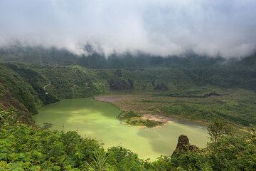
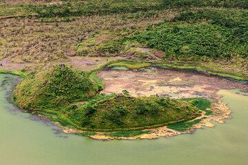
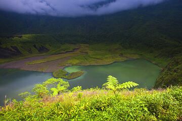
Galunggung volcano is a forested cone cut by a large horseshoe-shaped caldera breached to the SE where most pyroclastic flows from recent eruptions were channeled.
The "Ten Thousand Hills of Tasikmalaya" dotting the plain below the volcano are hill-size deposits (hummocks) left by a large debris-avalanche associated with the collapse forming the caldera ca. 4200 years ago.
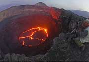
Historical eruptions have been restricted to the central vent near the caldera headwall. The eruptions from Galunggung have often caused much damage: The first historical eruption in 1822 produced pyroclastic flows and lahars that killed over 4000 persons. Its last major eruption in 1982-1983 produced devastating pyroclastic flows causing large-scale damage in the populated areas around the volcano.

Galunggung Volcano Photos

Significant volcanic eruptions: Galunggung volcano

In the past 10,000 years, Galunggung has had at least 6 confirmed volcanic eruptions, out of which 5 are documented by historical records, while the others can be inferred from geological evidence.
There is one uncertain or discredited eruption around 850 AD from Galunggung volcano.
The table below lists all known eruptions (date in bold face) of Galunggung volcano in historic times and during the past 10,000 years. Updates on the most recent volcanic activity of Galunggung can be found on the news page of Galunggung volcano.
DateNoteVEIDeathsDamage
1984 Jan 9 - Jan 31 ?
Historical obs./docs.
1
1982 Apr 5 - 1983 Jan 8New crater at Gunung Jadi location
Historical obs./docs.
4
1982 May 17
(eruption 1982 Apr 5 - 1983 Jan 8)
Historical obs./docs.
468
heavy
Info
1918 Jul 17 - Jul 30Gunung Jadi
Historical obs./docs.
1
1894 Oct 17 - Dec
Historical obs./docs.
3
1822 Oct 8 - Dec 1 ±30 d.
Historical obs./docs.
5
1822 Oct 8
(eruption 1822 Oct 8 - Dec 1 ±30 d.)
Historical obs./docs.
54,011
heavy
Info
?? 850 ±50 y. AD
Uncertain Eruption
?
2250 ±150 y. BC5?
Remark:
Our list of volcanic eruptions closely follows the database of eruptions of the Smithsonian's Global Volcanism Project (GVP), the internationally most recognized data source for volcanic eruptions, but also includes significant eruptive episodes or related volcano events. "Volcanic eruptions" are usually to be understood as sequences of individual eruptive episodes that can follow each other, or even overlap (if several vents are involved), and can last many years, decades or even longer. For example, the current activity of Stromboli volcano is understood as a single eruption that has been ongoing since 1934.
Sources: NOAA National Centers for Environmental Information (NCEI), Global Significant Volcanic Eruptions Database. doi:10.7289/V5TD9V7K | Global Volcanism Project / Smithsonian Institution

Eruptions of Galunggung volcano


April 1982 - Jan 1983 eruption
The 1982-1983 eruption was a series of violent explosions with tall ash plumes and pyroclastic flows and mud flows. It killed at least 21 people, caused evacuation of 40,000 people and destroyed ca 94,000 ha of cultivated land. ...more info

Aircraft ash encounter at Galunggung volcano - near fatal accident with Boing 474
On 24 June 1982, a Boeing 747 flew through Galunggung's undetected ash plume, which caused all four engines to fail. Fortunately, the engines could be restarted after the plane had lost 25,000 ft and came into denser air, and the crew managed a successful emergency landing, saving the lives of 263 people. This and a similar accident over Alaska raised awareness of the need to monitor volcanic ash plumes, which lead to the formation of the Volcanic Ash Advisory Centres (VAAC). ...more info

Galunggung Volcano FAQ

+When was the last eruption of Galunggung volcano?

+How often does Galunggung volcano erupt?

+How active is Galunggung volcano at present?

+When was the largest eruption of Galunggung volcano?

Latest satellite images

Galunggung satellite image sat1Galunggung satellite image sat2

Galunggung Volcano Maps

Below is a selection of maps showing the location and surroundings of the volcano at various resolutions based on aerial-imagery / terrain maps. Feel free to use them for non-commercial purposes on your blog or website as long as you credit them with a link back to this page (click to copy it).
Satellite/aerial-type map of Galunggung volcano (world scale)
Terrain-type map of Galunggung volcano (world scale)
Satellite/aerial-type map of Galunggung volcano (region scale large)
Terrain-type map of Galunggung volcano (region scale large)
Satellite/aerial-type map of Galunggung volcano (region scale medium)
Terrain-type map of Galunggung volcano (region scale medium)
Satellite/aerial-type map of Galunggung volcano (region scale small)
Terrain-type map of Galunggung volcano (region scale small)
Satellite/aerial-type map of Galunggung volcano (local scale large)
Terrain-type map of Galunggung volcano (local scale large)
Satellite/aerial-type map of Galunggung volcano (local scale medium)
Terrain-type map of Galunggung volcano (local scale medium)
Satellite/aerial-type map of Galunggung volcano (local scale small)
Terrain-type map of Galunggung volcano (local scale small)
Satellite/aerial-type map of Galunggung volcano (scale of 10s of km)
Terrain-type map of Galunggung volcano (scale of 10s of km)
Satellite/aerial-type map of Galunggung volcano (scale of 20-40 km)
Terrain-type map of Galunggung volcano (scale of 20-40 km)
Satellite/aerial-type map of Galunggung volcano (scale of approx. 10-20 km)
Terrain-type map of Galunggung volcano (scale of approx. 10-20 km)
Satellite/aerial-type map of Galunggung volcano (scale of 5-10 km)
Satellite/aerial-type map of Galunggung volcano (scale of few kilometers)
Volcanoes & Earthquakes - new app for Android
Guaranteed tours
9-25 Jun 2025: Volcanoes and Spices - Sulawesi/Halmahera (Indonesia)
7-22 Jul 2025: From Krakatau to Bali - Java (Indonesia)
7-23 Jul 2025: Volcanoes and Spices - Sulawesi/Halmahera (Indonesia)
1-17 Aug 2025: Volcanoes and Spices - Sulawesi/Halmahera (Indonesia)
1-14 Oct 2025: Desert, salt and volcanoes - Danakil desert (Ethiopia)
4-12 Oct 2025: From Stromboli to Etna - Sicily and Eolian Islands (Italy)
6-21 Oct 2025: From Krakatau to Bali - Java (Indonesia)
3-19 Nov 2025: Volcanoes and Spices - Sulawesi/Halmahera (Indonesia)
= spaces available   = guaranteed   = few spaces left   = booked out
Fri, 1 Jun 2012, 10:05

Galunggung volcano (West Java, Indonesia) activity update: decreasing activity, alert level lowered back to normal (green)

Since the Alert Level was raised on 12 February, seismic activity at Galunggung had drastically decreased through 27 May. Read all
Wed, 23 May 2012, 06:00

Galunggung volcano (Western Java, Indonesia) - Smithsonian / USGS Weekly Volcanic Activity Report for 23 May-29 May 2012 (New Activity / Unrest)

CVGHM reported that, since the Alert Level was raised on 12 February, seismic activity at Galunggung had drastically decreased through 27 May. During 27 April-27 May plants around the crater area looked green and lush, small fish were swimming in the water, and insects around the crater were active. Based on seismic data, crater lake water temperature and pH data, and visual observations, CVGHM lowered the Alert Level from 2 to 1 (on a scale of 1-4) on 28 May. ... Read all

On this page:

Try our free app!
Volcanoes & Earthquakes - new app for Android
Android | iOS version

More on VolcanoDiscovery

Why is there advertising on this site?

Support us - Help us upgrade our services!

We truly love working to bring you the latest volcano and earthquake data from around the world. Maintaining our website and our free apps does require, however, considerable time and resources.
We need financing to increase hard- and software capacity as well as support our editor team. We're aiming to achieve uninterrupted service wherever an earthquake or volcano eruption unfolds, and your donations can make it happen! Every donation will be highly appreciated. If you find the information useful and would like to support our team in integrating further features, write great content, and in upgrading our soft- and hardware, please make a donation (PayPal).

Planned features:Thanks to your past donations, these features have been added recently:
Download and Upgrade the Volcanoes & Earthquakes app to get one of the fastest seismic and volcano alerts online:
Android | IOS
Thank you!
Sources: VolcanoDiscovery / VolcanoAdventures and other sources as noted.
Use of material: Most text and images on our websites are owned by us. Re-use is generally not permitted without authorization. Contact us for licensing rights.
Volcanoes & Earthquakes
VolcanoDiscovery Home
Volcanoes | Earthquakes | Photos | Volcano News | | Shop | App
Adventure & Study Travel
Tours to Volcanoes and Volcanic Areas: walking tours, photo tours, study tours
Tours & Dates | FAQ | About us
Get our newsletter!
Company info
Contact | Legal info | Terms & conditions
Follow us
Follow us on facebook Follow us on Instagram Follow us on Bluesky Follow us on Twitter Visit our Youtube channel
EN | DE | EL | ES | FR | IT | RU
VolcanoDiscovery GmbH, Germany, Reg. nr.: HRB 103744, EU Tax Id: DE 297 465 123 owned and created by
Dr. Tom Pfeiffer, volcanologist, volcano photographer, tour organizer member of
IAVCEI
IAVCEI
Vulkanologische Gesellschaft
Volcanological Society
Ecotourism Greece
Ecotourism Greece
RUV insurance
Insured by R+V
VolcanoDiscovery © 2004- All Rights Reserved | Privacy - Cookie Settings