Contact | RSS | EN | DE | EL | ES | FR | IT | RU

Volcanoes of Tonga (22)

Ata Volcanic Complex | Curacoa | Feinga Seamount | Fonuafo'ou | Fonualei | Home Reef | Hunga Tonga-Hunga Ha'apai | Kao | Late | Metis Shoal (Lateiki) | Niuafo'ou | Tafahi | Tafu-Maka | Tofua | Toku | Unnamed | Unnamed 20.85°S/175.55°W | Unnamed 21.15°S/175.75°W | Unnamed 21.38°S/175.65°W | Unnamed 24.8°S/177.02°W | Unnamed 50 km NW of Vava’u (Tonga) | West Mata
[smaller] [bigger]

Volcano list

Ata Volcanic Complex

(Unknown 274 m / 899 ft)
[more info]

Curacoa

(Submarine volcano -33 m / - 108 ft)
[more info]

Feinga Seamount

(Submarine -393 m / -1289 ft)
[more info]

Fonuafo'ou

(Submarine volcano -17 m / -56 ft)
[more info]

Fonualei

(Stratovolcano 180 m / 591 ft)
[more info]

Home Reef

(submarine volcano -10 m / -33 ft)
Home Reef is a submarine volcano midway between Metis Shoal and Late Island in the central Tonga islands. It was first seen and reported to be active in the mid-19th century, when an ephemeral island formed.
An eruption in 1984 produced a 12-km-high eruption plume, copious... [more info]

Hunga Tonga-Hunga Ha'apai

(Submarine volcano 149 m / 489 ft)
The small islands of Hunga Tonga and Hunga Ha'apai cap a large seamount located about 30 km SSE of Falcon Island, approximately 65 km NW of Vuna Wharf, Nuku'alofa, and 70 km SW of Nomuka Island. [more info]

Kao

(Stratovolcano 1030 m / 3,379 ft)
[more info]

Late

(Stratovolcano 540 m / 1,772 ft)
[more info]

Metis Shoal (Lateiki)

(Submarine volcano 43 m / 141 ft)
Metis Shoal or officially renamed to Lateiki volcano is a submarine volcano midway between the islands of Kao and Late. It is frequently in eruption and has produced a series of ephemeral islands since the first confirmed activity in the mid-19th century. [more info]

Niuafo'ou

(Shield volcano 260 m / 853 ft)
[more info]

Tafahi

(Stratovolcano 560 m / 1,837 ft)
[more info]

Tafu-Maka

(Submarine volcano -1400 m / - 4,593 ft)
[more info]

Tofua

(caldera 515 m / 1,690 ft)
Aerial photo of Tofua (Tonga Ministry of Lands, Survey, and Natural Resources, 1990, published in Taylor and Ewart, 1997)
Tofua volcano is the subaerial part of a large frequently active stratovolcano. It forms the 8 km wide circular Tofua Island, dominated by the 5 km wide caldera containing a freshwater lake at only 30 m above sea level and surrounded by steep 300 m cliffs.
The island is kno... [more info]

Toku

(Submarine 21 m / 69 ft)
[more info]

Unnamed

(Submarine -331 m / -1086 ft)
[more info]

Unnamed 20.85°S/175.55°W

(Submarine volcano -13 m / - 43 ft)
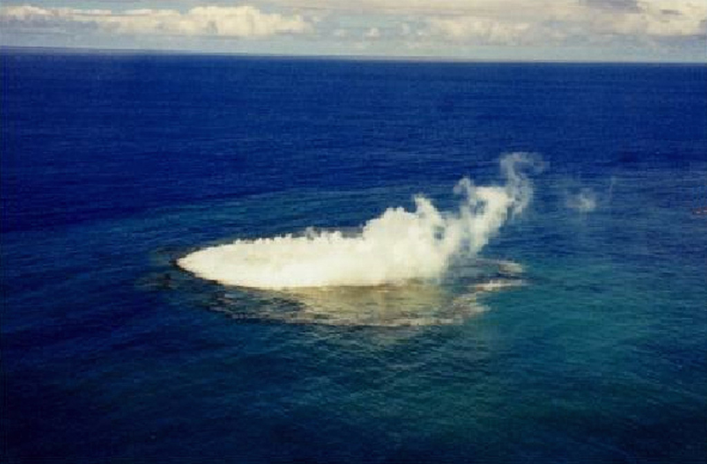
A plume and discolored water from a submarine eruption were observed in January 1999. This unnamed submarine volcano, 35 km NW of the Niu Aunofo lighthouse on Tongatapu Island, was constructed at the southern end of a submarine ridge segment of the Tofua volcanic arc extending NNE to Falcon Island. The first documented eruptions took place in 1911 and 1923. An ephemeral island was formed during this eruption in 1999; prior to this the summit was 13 m beneath the sea surface. (Photo by B. Hutchins, 1999, published in Taylor, 1999, via GVP)
[more info]

Unnamed 21.15°S/175.75°W

(Submarine volcano -65 m / - 213 ft)
[more info]

Unnamed 21.38°S/175.65°W

(Submarine volcano -500? m / - 1,640 ft)
[more info]

Unnamed 24.8°S/177.02°W

(Submarine volcano -385 m / - 1,263 ft)
[more info]

Unnamed 50 km NW of Vava’u (Tonga)

(Submarine volcano -40 m / - 131 ft)
[more info]

West Mata

(Submarine volcano -1174 m / - 3,852 ft)
[more info]

Tonga and Fiji Islands: volcano news & updates

Wed, 8 May 2024, 14:00

Tofua volcano (Tonga Ridge) - Smithsonian / USGS Weekly Volcanic Activity Report for 1 May-7 May 2024 (New Activity / Unrest)

Tonga Geological Services reported that unrest at Tofua continued during 1-7 May. Thermal anomalies with varying intensities were detected daily. Sulfur dioxide plumes from the 28 April emission event continued to be identified in satellite data during 1-2 May. ... Read all
Try our free app!
Volcanoes & Earthquakes - new app for Android
Android | iOS version

More on VolcanoDiscovery

Why is there advertising on this site?

Support us - Help us upgrade our services!

We truly love working to bring you the latest volcano and earthquake data from around the world. Maintaining our website and our free apps does require, however, considerable time and resources.
We need financing to increase hard- and software capacity as well as support our editor team. We're aiming to achieve uninterrupted service wherever an earthquake or volcano eruption unfolds, and your donations can make it happen! Every donation will be highly appreciated. If you find the information useful and would like to support our team in integrating further features, write great content, and in upgrading our soft- and hardware, please make a donation (PayPal or Online credit card payment).

Planned features:Thanks to your past donations, these features have been added recently:
Download and Upgrade the Volcanoes & Earthquakes app to get one of the fastest seismic and volcano alerts online:
Android | IOS
Thank you!
Sources: VolcanoDiscovery / VolcanoAdventures and other sources as noted.
Use of material: Most text and images on our websites are owned by us. Re-use is generally not permitted without authorization. Contact us for licensing rights.
Volcanoes & Earthquakes
VolcanoDiscovery Home
Volcanoes | Earthquakes | Photos | Volcano News | App
Adventure & Study Travel
Tours to Volcanoes and Volcanic Areas: walking tours, photo tours, study tours
Tours & Dates | FAQ | About us
Get our newsletter!
Company info
Contact | Legal info | Terms & conditions
Follow us
Follow us on facebook Follow us on Instagram Follow us on Twitter Visit our Youtube channel
EN | DE | EL | ES | FR | IT | RU
VolcanoDiscovery GmbH, Germany, Reg. nr.: HRB 103744, EU Tax Id: DE 297 465 123 owned and created by
Dr. Tom Pfeiffer, volcanologist, volcano photographer, tour organizer member of
IAVCEI
IAVCEI
Vulkanologische Gesellschaft
Volcanological Society
Ecotourism Greece
Ecotourism Greece
RUV insurance
Insured by R+V
VolcanoDiscovery © 2004- All Rights Reserved | Privacy - Cookie Settings