| Date | Volcano | VEI | Region | Deaths | Damage | |
|---|---|---|---|---|---|---|
| Tofua Lofia crater | 0 | Tonga Islands | ||||
| Home Reef | ? | Tonga Islands | ||||
| Home Reef | ? | Tonga Islands | ||||
| Home Reef | 1 | Tonga Islands | ||||
| Home Reef | 2 | Tonga Islands | ||||
| Hunga Tonga-Hunga Ha'apai | 5 | Tonga, Tonga Islands | ||||
| 2022 Jan 15 (eruption | Hunga Tonga-Hunga Ha'apai | 5 | Tonga, Tonga Islands | 6 | very heavy | Info |
| Metis Shoal (Lateiki) | 1 | Tonga, Tonga Islands | ||||
| Unnamed 50 km NW of Vava’u (Tonga) | 3 | 50 km NW of Vava’u, Tonga Islands | ||||
| Unnamed 20.85°S/175.55°W Submarine | 0 | Tonga, Tonga Islands | ||||
| Hunga Tonga-Hunga Ha'apai about 1 km SW of Hunga Tonga and 1 km E of Hunga Ha'apai islands | 2 | Tonga, Tonga Islands | ||||
| Tofua Lofia crater | 1? | Tonga Islands | ||||
| West Mata Prometheus and Hades vents | 0 | Tonga, Tonga Islands | ||||
| Hunga Tonga-Hunga Ha'apai Hunga Ha'apai | 2 | Tonga, Tonga Islands | ||||
| Tafu-Maka Maka | 0 | Tonga, Tonga Islands | ||||
| Home Reef | 2? | Tonga Islands | ||||
| Unnamed 50 km NW of Vava’u (Tonga) | 2 | 50 km NW of Vava’u, Tonga Islands | ||||
| Unnamed 20.85°S/175.55°W | 1 | Tonga, Tonga Islands | ||||
| Metis Shoal (Lateiki) | 2 | Tonga, Tonga Islands | ||||
| Metis Shoal (Lateiki) | 0 | Tonga, Tonga Islands | ||||
| Hunga Tonga-Hunga Ha'apai 1 km SSE of Hunga Ha'apai | 0 | Tonga, Tonga Islands | ||||
| Home Reef | 3? | Tonga Islands | ||||
| Metis Shoal (Lateiki) | 2 | Tonga, Tonga Islands | ||||
| Curacoa 13 km north of Tafahi | 1 | Tonga, Tonga Islands | ||||
| Curacoa 6.4 km SW of Curacoa Reef | 3 | Tonga, Tonga Islands | ||||
| Metis Shoal (Lateiki) | 2 | Tonga, Tonga Islands | ||||
| Tofua Northern part of caldera | 2 | Tonga Islands | ||||
| Fonualei | ? | Tonga, Tonga Islands | ||||
| Fonualei North-central part of the island | 2 | Tonga, Tonga Islands | ||||
| Niuafo'ou North flank | 2 | Tonga, Tonga Islands | ||||
| Niuafo'ou SW flank | 2 | Tonga, Tonga Islands | ||||
| Fonualei Summit, W and SE sides | 2 | Tonga, Tonga Islands | ||||
| Hunga Tonga-Hunga Ha'apai | 2 | Tonga, Tonga Islands | ||||
| Fonuafo'ou | 2 | Tonga, Tonga Islands | ||||
| Niuafo'ou South flank | 2 | Tonga, Tonga Islands | ||||
| Fonuafo'ou | 2 | Tonga, Tonga Islands | ||||
| Unnamed 21.38°S/175.65°W | 0 | Tonga, Tonga Islands | ||||
| Niuafo'ou West flank | 2 | Tonga, Tonga Islands | ||||
| Fonuafo'ou | 2 | Tonga, Tonga Islands | ||||
| Unnamed 20.85°S/175.55°W | 0 | Tonga, Tonga Islands | ||||
| Niuafo'ou West side, near Alele 'Uta village | 2 | Tonga, Tonga Islands | ||||
| Hunga Tonga-Hunga Ha'apai | 2 | Tonga, Tonga Islands | ||||
| Unnamed 20.85°S/175.55°W | 0 | Tonga, Tonga Islands | ||||
| Unnamed 21.38°S/175.65°W | 0 | Tonga, Tonga Islands | ||||
| Tofua Northern part of caldera | 2 | Tonga Islands | ||||
| Fonualei | ? | Tonga, Tonga Islands | ||||
| Tofua Northern part of caldera | 2 | Tonga Islands | ||||
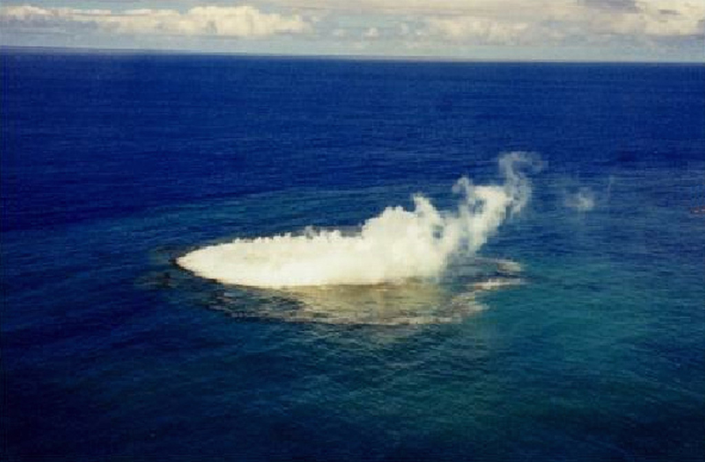
The last volcanic eruption in Tonga was from Home Reef volcano in 2024.
The first historically documented eruption occurred 1774 from Tofua volcano.
Since 1774, Tonga has seen at least 68 historically documented eruptions. This means that a volcano erupts on average every 3.7 years.
Tonga is volcanically relatively active: Since 1900, at least 13 volcanoes in Tonga have been active.Since 1900, Tonga has had 46 volcanic eruptions from 13 individual volcanoes. Volcanic eruptions have been recorded erupted during 53 years out of 126 as of now. This means, at least one volcano in Tonga has been in eruption in one in 2.4 years on average. The last volcano to erupt in Tonga was Home Reef volcano, which erupted in 2024, 5 months ago.
The largest eruption in Tonga in historic times was from Hunga Tonga-Hunga Ha'apai volcano. It occurred during 2021 - 2022. It ranks as a plinian eruption with a magnitude 5 on the VEI (Volcanic Explosivity Index) scale. Eruption of this size are often catastrophic on a regional scale.
| Date and Time | Mag / Depth | Nearest Volcano / Location | |||
|---|---|---|---|---|---|
| May 19, 03:24 am (GMT -12) | 5.1 10 km | 208 km (129 mi) E of | South Pacific Ocean, 360 km south of 'Eua Island, Eua, Tonga I FELT IT | Info | |
| May 19, 01:11 pm (GMT +13) | 4.3 370 km | 72 km (45 mi) SW of | South Pacific Ocean, 347 km northwest of Neiafu, Vava'u, Tonga I FELT IT | Info | |
| Sunday, May 18, 2025 GMT (1 quake) | |||||
| May 18, 08:54 pm (GMT +13) | 4.9 76 km | 52 km (32 mi) N of | South Pacific Ocean, 131 km northwest of Neiafu, Vava'u, Tonga I FELT IT - 1 report | Info | |
| Saturday, May 17, 2025 GMT (1 quake) | |||||
| May 18, 09:56 am (GMT +13) | 4.7 93 km | 49 km (30 mi) N of | South Pacific Ocean, 126 km north of Neiafu, Vava'u, Tonga I FELT IT | Info | |
| Date | Mag | Region | Deaths | Damage | |
|---|---|---|---|---|---|
| 2006 May 3 | 7.9 | Tonga Islands | 0 | light | Info |
| 1977 Jun 22 | 7.2 | Tonga Trench | 1 | light | Info |
| 1977 Apr 2 | 7.6 | Samoa Islands: Apia | 0 | light | Info |
| 1919 Apr 30 | 8.1 | Tonga Islands | 0 | light | Info |
The deadliest earthquake in Tonga since 1900 was the magnitude 7.2 earthquake in ![]() Tonga on Jun, 22, 1977. It resulted in 1 fatalities and 5 injured people. A tsunami was generated by the quake as well and contributed to its desctuctive effects. This was the most disastrous quake in Tonga ever recorded.
Tonga on Jun, 22, 1977. It resulted in 1 fatalities and 5 injured people. A tsunami was generated by the quake as well and contributed to its desctuctive effects. This was the most disastrous quake in Tonga ever recorded.
Since 1900, at least 1 earthquakes claimed an estimated total of 1 fatalities in Tonga.
There were 4 damaging or deadly quakes during this period that caused economic losses of approx. $4.2 million US Dollars combined.